Veteran's Day
at
Wilson's Creek Battlefield
by John Dunn
photography by Chris Dunn
(Click on the thumbnails for larger photos. Be advised a few of them are somewhat large.)
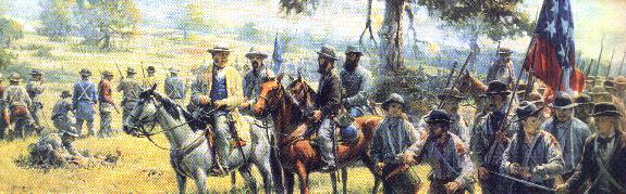
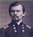
Maj. Gen. Sterling Price & the Missouri National Guard from the painting "Don't Yield an Inch" by Andy Thomas.
INTRODUCTION.
On November 11, 2002,
Veteran's Day, my brother Chris and I took a trip to the Wilson's Creek National
Battlefield. It was arguably the last day of decent weather this year and it
seemed a good way to observe the day we honor our Nation's veterans. On August
10, 1861, the Battle of Wilson's Creek was fought ("a mean fought
fight" according to one contemporary) that turned red the waters of
Wilson's Creek. The battle was a Rebel victory but
ultimately resulted in Missouri remaining outside the Confederacy.
day we honor our Nation's veterans. On August
10, 1861, the Battle of Wilson's Creek was fought ("a mean fought
fight" according to one contemporary) that turned red the waters of
Wilson's Creek. The battle was a Rebel victory but
ultimately resulted in Missouri remaining outside the Confederacy.
I live near enough to Springfield, Missouri that the battlefield is a mere ten minute drive from where I live, yet I have not seen this place since I was a kid! I decided it was time to correct this oversight. My brother, a skilled photographer, came with me and captured these photos (except of course for the scans of paintings) for your enjoyment.
Please note that the point of this work is neither to assume a political opinion of the events of the Civil War or to attempt any sort of historical thesis, a subject on which I am an armchair scholar at best. History buffs can do their own research on the particulars of the battle. I wrote this article for my own enjoyment and to bring you a photographic view of this bit of Ozarks history. A lot of the ladies and gentlemen who frequent the bulletin boards of www.milesfortis.com and www.sixgunner.com and elsewhere are themselves informal scholars of American history and of the Civil War in particular, yet don't have reason or opportunity to visit Missouri very often.
Therefore this article is for you. Enjoy our photo journal of our visit to Wilson's Creek Battlefield and make of it what you will. For a better view of it click here to visit the official Wilson's Creek Battlefield website courtesy of the US Department of the Interior. They've done an outstanding job of preserving this historic site.
THE PARK ITSELF.
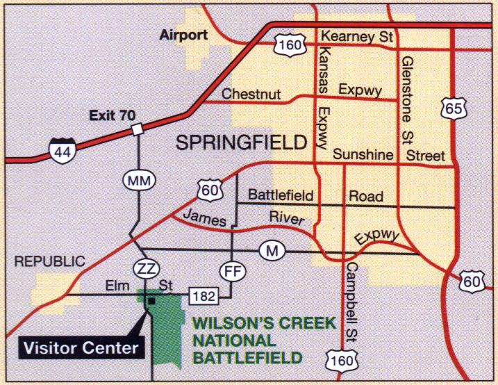 Finding
the park itself is easy. Once you get to the Greene County area just make your
way James River Expressway and follow the big brown Park Department signs. Click
on the attached map for some assistance. The drive itself makes for a relaxing
country ride during an Ozarks autumn. The temperature was in the lower 60s,
and while the wind was making itself felt that day it wasn't so bad as to keep
people away from the park.
Finding
the park itself is easy. Once you get to the Greene County area just make your
way James River Expressway and follow the big brown Park Department signs. Click
on the attached map for some assistance. The drive itself makes for a relaxing
country ride during an Ozarks autumn. The temperature was in the lower 60s,
and while the wind was making itself felt that day it wasn't so bad as to keep
people away from the park.
The folks who
work here are kind and helpful. They cheerfully answered any
questions we had, and from the lady at the main counter in the visitor's center
to the park rangers themselves (one of whom was even kind enough to ring up the
souvenirs I bought at their gift shop) they make sure you enjoy your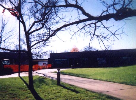 stay. Be advised however that metal detectors and souvenir-hunting on the
grounds themselves are strictly prohibited.
stay. Be advised however that metal detectors and souvenir-hunting on the
grounds themselves are strictly prohibited.
The visitor's center itself, pictured here, is undergoing some construction to add a large library dedicated to Civil War historical research. You can see the orange "Do Not Cross" fencing across the incomplete areas. Inside you will find a small but comfortable amphitheatre that shows an informational 13-minute film that explains the events leading up to the battle, numerous displays of artifacts (including an outstanding display of General Price's engraved, ivory-handled Colt revolver) and an impressive fiber-optic live-action display on a realistic, high-tech 3-D topographical recreation of how the battle itself played out.
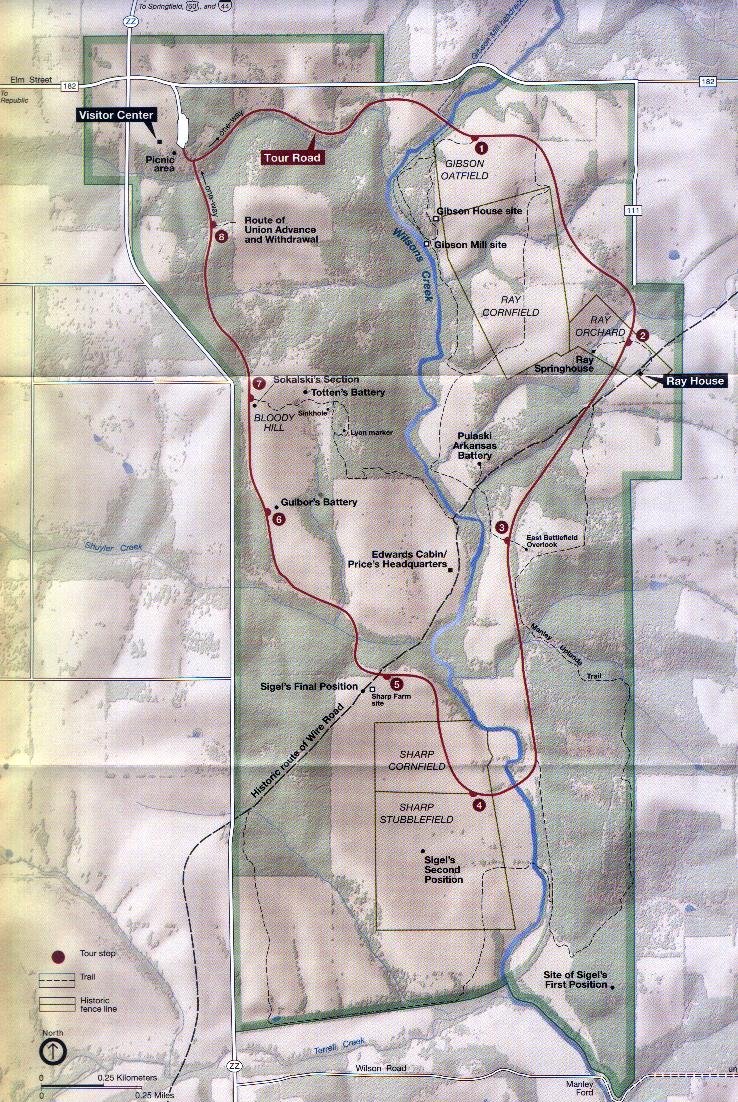 The
main tour itself consists of a slow, winding drive around the park. There
are numerous places to pull off the road and walk to one of the important sites.
For that matter, hike or ride horseback on one of the several trails if you
like, including
along the original historical Old Wire Road that connected Springfield, Missouri
with Fort Smith, Arkansas via telegraph.
The
main tour itself consists of a slow, winding drive around the park. There
are numerous places to pull off the road and walk to one of the important sites.
For that matter, hike or ride horseback on one of the several trails if you
like, including
along the original historical Old Wire Road that connected Springfield, Missouri
with Fort Smith, Arkansas via telegraph.
You can easily take an entire day slowly driving from site to site. Picnic facilities and clean restrooms are provided near the Visitor's Center and admission is $3.00 per person or $5.00 per carload. This buys you a brass token that will let you through the electric gate. If you're a frequent visitor, a year-round pass can be had for $15.00.
BEGINNING THE TOUR.
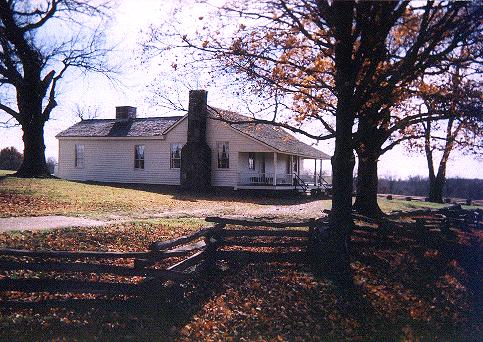 The
first stop along the tour is the Ray House, pictured below and on the left. It was
constructed sometime around 1852 and is the best preserved structure in the park. It was
from here that John Ray watched the battle commence from his front porch as
Federal troops and Missouri volunteers charged back and forth across his corn
field. Before long Union troops had commandeered the place for use as a field
hospital. The house quickly filled up with wounded Union soldiers who eventually overflowed
onto the porch and into the front lawn.
The
first stop along the tour is the Ray House, pictured below and on the left. It was
constructed sometime around 1852 and is the best preserved structure in the park. It was
from here that John Ray watched the battle commence from his front porch as
Federal troops and Missouri volunteers charged back and forth across his corn
field. Before long Union troops had commandeered the place for use as a field
hospital. The house quickly filled up with wounded Union soldiers who eventually overflowed
onto the porch and into the front lawn.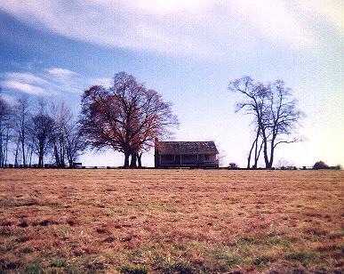
Even the furnishings of the old house have been preserved. Through the windows
you can see a spinning wheel for making cloth, original furniture, even place settings at the
dining room table next to the old fireplace. Across the front lawn and
just into the edge of his corn field (and across the tour road) are the  still-standing remains of Mr. Ray's spring
house. This was his well as well as a cool, convenient place to store perishables such as eggs and butter. Mr. Ray,
his wife and children carried buckets
of water from here (the two photos on the left) to the doctors who tended the wounded.
I have to say the place had a rather eerie feel to it, as though you could
still sense the grim purpose it was put to.
still-standing remains of Mr. Ray's spring
house. This was his well as well as a cool, convenient place to store perishables such as eggs and butter. Mr. Ray,
his wife and children carried buckets
of water from here (the two photos on the left) to the doctors who tended the wounded.
I have to say the place had a rather eerie feel to it, as though you could
still sense the grim purpose it was put to.
Small addition (since I was obliquely involved) by the webmaster, who is also a line technician for Southwestern Bell Telephone: The Ray house was completely restored in 1983. I put the phone line in for the contractor's trailer. We had to run lines overhead, through trees and attaching to any available existing utility pole as any form of excavation entailed the need for a Federal permit, archaeology survey and an on-site forensic archaeologist, just in case we dug up a Minie' ball. --Miles
 There was almost no one else there
at the time Chris and I were taking photographs. This seemed to lend a
surreal feeling to the place as though we'd just walked into a ghost town. The Ray family had a slave, the children's
"aunt",
who had a small cabin behind the house itself, but
There was almost no one else there
at the time Chris and I were taking photographs. This seemed to lend a
surreal feeling to the place as though we'd just walked into a ghost town. The Ray family had a slave, the children's
"aunt",
who had a small cabin behind the house itself, but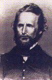 it and the
old chicken house are long gone, long since destroyed by artillery fire from a
high point overlooking the cornfield. The house was untouched...and it was here
that the body of Union commander Brigadier General Nathaniel Lyon was brought
when he fell in battle. Having already been wounded twice, he stayed in the fray
until a Confederate musket ball struck him in the chest and shot him off his
horse.
it and the
old chicken house are long gone, long since destroyed by artillery fire from a
high point overlooking the cornfield. The house was untouched...and it was here
that the body of Union commander Brigadier General Nathaniel Lyon was brought
when he fell in battle. Having already been wounded twice, he stayed in the fray
until a Confederate musket ball struck him in the chest and shot him off his
horse.
ARTILLERY.
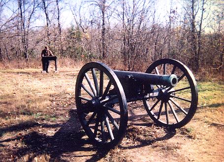 Several
artillery pieces have been preserved and secured down on concrete bases in their
original battery positions. My brother got quite a few photographs of them that
turned out quite well.
Here they are, in no particular order. This first one is the Pulaski, Arkansas
battery. It consists of one surviving piece. This Confederate artillery position
was all
that stood between the respected Major General Sterling Price (commander of the
Confederate forces and nicknamed "Old Pap") and a sneak attack by
General Lyon's advance from the north, a maneuver he tried unsuccessfully to
coordinate with Colonel Sigel's artillery from the south (see below).
Several
artillery pieces have been preserved and secured down on concrete bases in their
original battery positions. My brother got quite a few photographs of them that
turned out quite well.
Here they are, in no particular order. This first one is the Pulaski, Arkansas
battery. It consists of one surviving piece. This Confederate artillery position
was all
that stood between the respected Major General Sterling Price (commander of the
Confederate forces and nicknamed "Old Pap") and a sneak attack by
General Lyon's advance from the north, a maneuver he tried unsuccessfully to
coordinate with Colonel Sigel's artillery from the south (see below).
 Because
of the rainy weather the Confederate forces had scrapped plans to press on,
fearing their black powder ammunition would get wet. Oddly, when the Confederate forces
resumed their camp along the banks of Wilson's Creek, they had not reset their
pickets. This allowed the Union forces to creep up without warning in the early
hours of August 10, 1861. The Confederate artillerymen saw them coming however
from their position above a gulch near the creek itself and opened fire, buying time
for the Confederate infantry to form into line of battle and repel Lyon's
advance.
Because
of the rainy weather the Confederate forces had scrapped plans to press on,
fearing their black powder ammunition would get wet. Oddly, when the Confederate forces
resumed their camp along the banks of Wilson's Creek, they had not reset their
pickets. This allowed the Union forces to creep up without warning in the early
hours of August 10, 1861. The Confederate artillerymen saw them coming however
from their position above a gulch near the creek itself and opened fire, buying time
for the Confederate infantry to form into line of battle and repel Lyon's
advance.
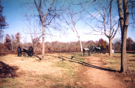 Here
Captain Henry Guibor dueled with Union artillery on the crest of
"Bloody Hill". Despite his bombardments and three Confederate attacks
through the fields the Union line held. On the fourth assault he saw that the Federals
had abandoned the crest and were withdrawing.
Here
Captain Henry Guibor dueled with Union artillery on the crest of
"Bloody Hill". Despite his bombardments and three Confederate attacks
through the fields the Union line held. On the fourth assault he saw that the Federals
had abandoned the crest and were withdrawing.
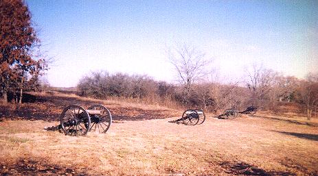
These three
photographs provide more images of General Lyon's cannon perched on Bloody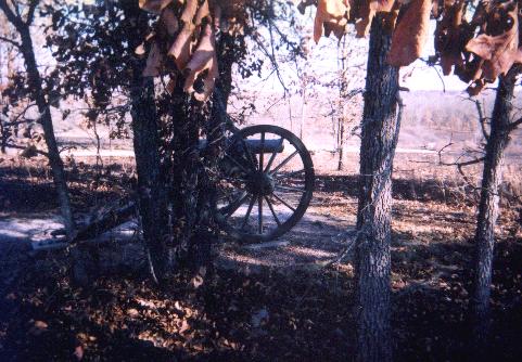 Hill, where the
  fiercest
fighting took
place. The one in the middle is "Totten's Battery."
fiercest
fighting took
place. The one in the middle is "Totten's Battery."
![]()
 Colonel
Sigel's third and final position in his northerly advance is pictured here.
Colonel
Sigel's third and final position in his northerly advance is pictured here. He was trying to coordinate his attack of the
Confederate rear with Lyon's advance from the north. Poor communications made this difficult
and the maneuver was largely unsuccessful. German-born Franz Sigel was colonel
of the 3rd Missouri Infantry and took part in the capture of Camp Jackson in
May, 1861. Here his force was outnumbered and his retreat helped ensure a Southern victory.
He was trying to coordinate his attack of the
Confederate rear with Lyon's advance from the north. Poor communications made this difficult
and the maneuver was largely unsuccessful. German-born Franz Sigel was colonel
of the 3rd Missouri Infantry and took part in the capture of Camp Jackson in
May, 1861. Here his force was outnumbered and his retreat helped ensure a Southern victory.
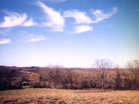
BLOODY HILL.
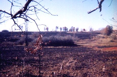 Throughout
the battle General Lyon's 4200-man command held the high ground which
eventually became known as Bloody Hill. When Chris and I visited the
place the Park Service had recently completed a controlled burn of the area to
remove weeds and undergrowth. The ground was left blackened and stunted, again
leaving an eerie feeling as though "this just happened yesterday." By
early morning August 10 1861 white smoke from the black powder guns covered the entire south slope. There
were over 1700 Union and Confederate casualties, among them General Lyon
himself.
Throughout
the battle General Lyon's 4200-man command held the high ground which
eventually became known as Bloody Hill. When Chris and I visited the
place the Park Service had recently completed a controlled burn of the area to
remove weeds and undergrowth. The ground was left blackened and stunted, again
leaving an eerie feeling as though "this just happened yesterday." By
early morning August 10 1861 white smoke from the black powder guns covered the entire south slope. There
were over 1700 Union and Confederate casualties, among them General Lyon
himself.
Not far
from here is a stone marker placed here in 1928 denoting the very spot where he
was killed. It reads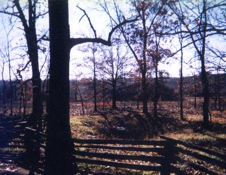 as
follows: "At or Near this spot fell Brigadier General Nathaniel Lyon,
born Ashford, Conn., 1818 graduated U.S. Military Academy,
1841. Commander of
the South, who, on this field, died
for the right as God gave them to see the right. 1928."
as
follows: "At or Near this spot fell Brigadier General Nathaniel Lyon,
born Ashford, Conn., 1818 graduated U.S. Military Academy,
1841. Commander of
the South, who, on this field, died
for the right as God gave them to see the right. 1928."
Despite this
honor, the
history I've read records Lyon as a reactionary and a butcher of peaceful Native
Americans. He was "Captain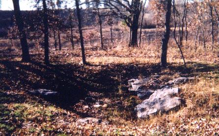 Lyon" till an overzealous, pro-Union
Missouri congressman named Francis P. Blair pulled some strings to get him promoted straight to Brigadier
General and ordered him to pursue the fleeing, Southern sympathizing Missouri governor and his
forces. Not far away is a sinkhole where 30 Union soldiers were hastily buried
(photos, right).
Lyon" till an overzealous, pro-Union
Missouri congressman named Francis P. Blair pulled some strings to get him promoted straight to Brigadier
General and ordered him to pursue the fleeing, Southern sympathizing Missouri governor and his
forces. Not far away is a sinkhole where 30 Union soldiers were hastily buried
(photos, right).
WILSON'S CREEK.
 Wilson's
Creek itself is a quiet, peaceful waterway that winds its way through the park.
Confederate forces were camped up and down both sides of it just before the
battle. Gen. Price's HQ was situated nearby (see below). At first glance it
looks like a nice place to fish
Wilson's
Creek itself is a quiet, peaceful waterway that winds its way through the park.
Confederate forces were camped up and down both sides of it just before the
battle. Gen. Price's HQ was situated nearby (see below). At first glance it
looks like a nice place to fish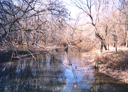 out of or camp next to, but this would be a bad
idea. The battlefield is a few short miles from
Springfield's local waste water treatment facility and Wilson's Creek flows not far
past it. Signs proclaiming the water is hazardous to humans are found at the
tour road entrance by the token-gate and on the bridge over the creek itself.
It's definitely look-but-don't-touch.
out of or camp next to, but this would be a bad
idea. The battlefield is a few short miles from
Springfield's local waste water treatment facility and Wilson's Creek flows not far
past it. Signs proclaiming the water is hazardous to humans are found at the
tour road entrance by the token-gate and on the bridge over the creek itself.
It's definitely look-but-don't-touch.
The scenery does make for some beautiful photography, but you have to be careful with that observation when you remember what happened here along these banks 141 years ago. At least one chronicler described how the waters ran red with the blood of dead men.
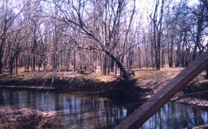 Not far from the old iron-and-plank bridge where these photos were taken was the
next stopping point along the tour trail: the original position of Sterling Price's headquarters. It sits a short ways north of Sharp's Cornfield
from where Colonel Sigel's infantry and artillery advance came. An old man named
Edwards had a small cabin
Not far from the old iron-and-plank bridge where these photos were taken was the
next stopping point along the tour trail: the original position of Sterling Price's headquarters. It sits a short ways north of Sharp's Cornfield
from where Colonel Sigel's infantry and artillery advance came. An old man named
Edwards had a small cabin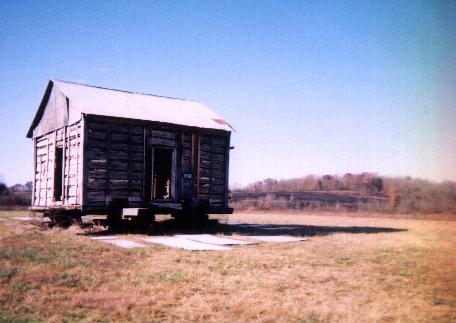 there and this was commandeered as
General Price's field
HQ. The original cabin is long gone but the old chap who's home it was
had a similar abode farther up the creek, so to give an impression of what the
spot may have originally looked like the park service uprooted the second cabin and set it down on the
spot where the first one had sat.
We captured the image in the photo to the right.
there and this was commandeered as
General Price's field
HQ. The original cabin is long gone but the old chap who's home it was
had a similar abode farther up the creek, so to give an impression of what the
spot may have originally looked like the park service uprooted the second cabin and set it down on the
spot where the first one had sat.
We captured the image in the photo to the right.
SOUVENIRS.
 I
hope the reader will not feel that I'm trivializing the history of the battle by
adding this last part but I'd like to pay some respect to the neat-o-rama gift
shop at the park's Visitor's Center. Of immediate interest are the historical
books they have for sale that I'd not seen in any "ordinary" book
shop. Quite a selection was available, from historical diatribes (of varying
degrees of objectivity of course) to collections of letters and journals written by
soldiers who had actually fought there. Naturally there was a focus on books
that described the Battle of Wilson's Creek itself, such as the one I bought, but one could also find all sorts of
overall material on
the War itself.
I
hope the reader will not feel that I'm trivializing the history of the battle by
adding this last part but I'd like to pay some respect to the neat-o-rama gift
shop at the park's Visitor's Center. Of immediate interest are the historical
books they have for sale that I'd not seen in any "ordinary" book
shop. Quite a selection was available, from historical diatribes (of varying
degrees of objectivity of course) to collections of letters and journals written by
soldiers who had actually fought there. Naturally there was a focus on books
that described the Battle of Wilson's Creek itself, such as the one I bought, but one could also find all sorts of
overall material on
the War itself.
Then there are the souvenirs. :-)
Allow me to show you my favorite one: the reproduction of a Civil War era
poker deck. Per the advertisement on the box, the cards have "full-length
court figures; decks used during the Civil War did not
have corner
indices." A sample of the numerical cards is pictured above on the left. A pair
of informational cards
inside the box provides some detail about early American playing cards.
Originally card-playing was illegal in America and considered an uncouth way to pass the
time. Decks of cards persisted in the hands of soldiers and gentlemen anyway.
The featured box (pictured right) has a reproduction of the original
two-cent proprietary tax stamps valid from 1862-1871. The cancellation date on
the facsimile is June 2, 1864. The author supposes that the governmental powers
that be, having decided that poker-playing and card game ownership couldn't be
prevented, gave up making them a moral stigma and just decided to tax them
instead.
the Civil War did not
have corner
indices." A sample of the numerical cards is pictured above on the left. A pair
of informational cards
inside the box provides some detail about early American playing cards.
Originally card-playing was illegal in America and considered an uncouth way to pass the
time. Decks of cards persisted in the hands of soldiers and gentlemen anyway.
The featured box (pictured right) has a reproduction of the original
two-cent proprietary tax stamps valid from 1862-1871. The cancellation date on
the facsimile is June 2, 1864. The author supposes that the governmental powers
that be, having decided that poker-playing and card game ownership couldn't be
prevented, gave up making them a moral stigma and just decided to tax them
instead.
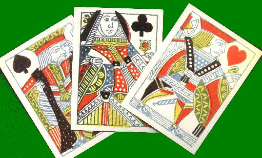 These
cards, originally printed by L. I. Cohen of New York, NY, were advertised as
having an "ivory-surfaced finish" and continued to be sold during the
1860s. The original Ace of Spades, seen in the above photo, was a blue spade
with an eagle beneath 13 stars and the name "L. I. Cohen" on the
bottom. This $6.00 tourist's delight reproduces the original Ace plus includes a
more traditional one (seen in the "Dead Man's Hand", above) for ease
of play. The court cards in this photo are full-length figures; you can tell the
Kings and Jacks apart by observing that the Kings have a beard, yet the Jacks
all stand on some sort of wall or foundation.
These
cards, originally printed by L. I. Cohen of New York, NY, were advertised as
having an "ivory-surfaced finish" and continued to be sold during the
1860s. The original Ace of Spades, seen in the above photo, was a blue spade
with an eagle beneath 13 stars and the name "L. I. Cohen" on the
bottom. This $6.00 tourist's delight reproduces the original Ace plus includes a
more traditional one (seen in the "Dead Man's Hand", above) for ease
of play. The court cards in this photo are full-length figures; you can tell the
Kings and Jacks apart by observing that the Kings have a beard, yet the Jacks
all stand on some sort of wall or foundation.
Interested parties can find these cards as well as other, more esoteric reproduction card games at the distributor's website by clicking here.
One more
souvenir went home with me: for the princely sum of $1.50 I took home a
crinkly, artificially-aged map of the battlefields of the Civil War. The
"parchment" map, suitable for wall-mounting, has all the battlefield
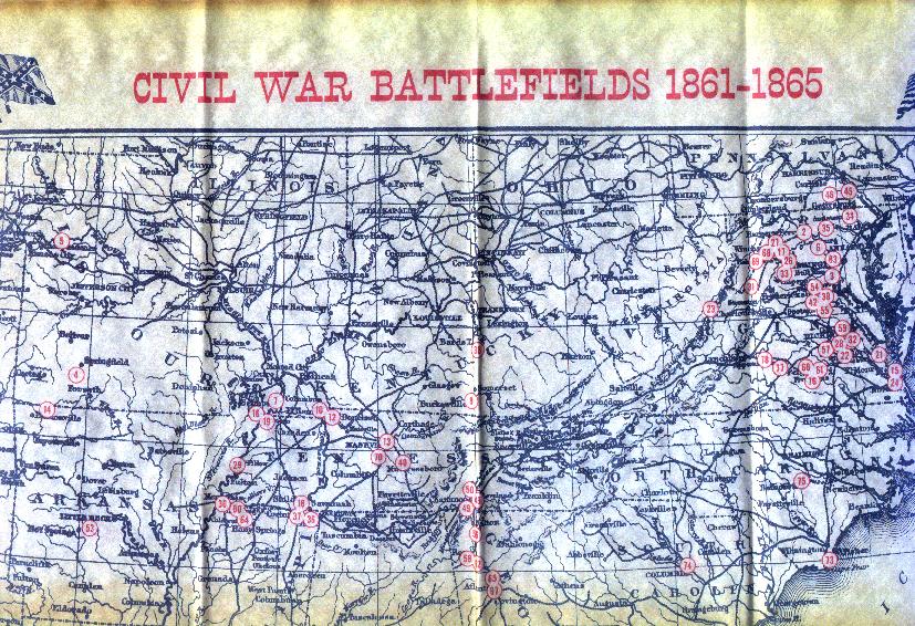 sites marked in red in chronological order. I imagine most folks
reading
this who have ever
visited an Americana-style gift shop has already seen one of these, but just for
completion's sake I'll include a couple of scans of it here anyway. Be advised
they are somewhat large and may take a minute or two to download on a slow
connection. The whole surface of this "campaign map" is a wonderful
crackly parchment yellow but under the bright lamp of my image scanner this is
only evident in the edges of each image.
sites marked in red in chronological order. I imagine most folks
reading
this who have ever
visited an Americana-style gift shop has already seen one of these, but just for
completion's sake I'll include a couple of scans of it here anyway. Be advised
they are somewhat large and may take a minute or two to download on a slow
connection. The whole surface of this "campaign map" is a wonderful
crackly parchment yellow but under the bright lamp of my image scanner this is
only evident in the edges of each image.
CONCLUSION.
This was a fun and informative trip to see an important part of American history and it was practically in my own back yard. I will probably pay another visit in the springtime to walk the trails that we didn't have time for on this visit; the pictures I've shown you here certainly do not cover the entire site. Any historical or visual errors are purely my own and are of no fault of the US Park Service. I hope you enjoyed this photo essay.
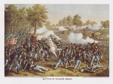
The Battle of Wilson's Creek, artist unknown. General Lyon is killed while astride his horse.
visitors since website crashed AUG 2003. Publish date was 24 Nov 2002.